


A specialized underwater expedition off the coast of southeastern France has successfully explored the wreckage of a 16th-century merchant vessel, marking a significant milestone in deep-sea archaeology. Resting at a depth of 2,500 meters—approximately 1.5 miles—the site, designated as Camarat 4, is officially the deepest shipwreck ever identified in French territorial waters. Utilizing advanced robotic technology, a joint team from the French Navy and the Department of Underwater and Submarine Archaeological Research (DRASSM) spent several days in April 2026 mapping the debris field and recovering artifacts that have remained undisturbed for nearly five centuries.
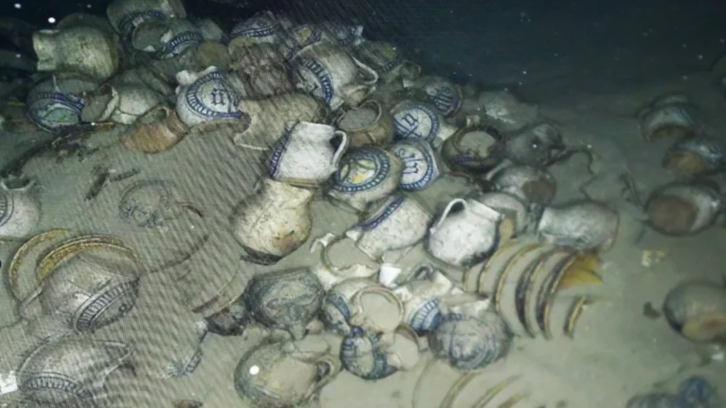
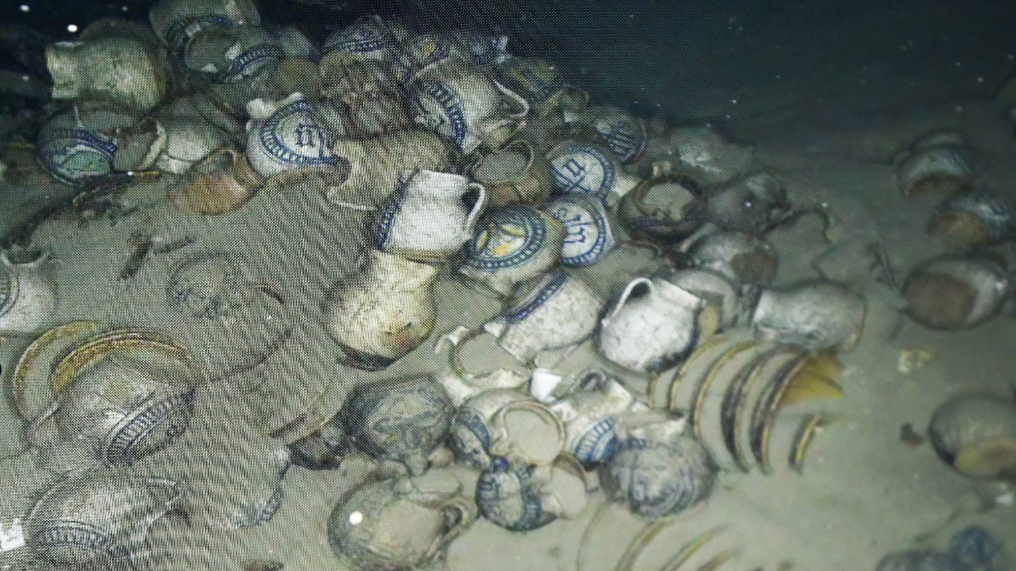
The mission, conducted from the bridge of the BSAA Jason, relied on the ROV C 4000, a high-performance remotely operated vehicle manufactured by LD Travocean. This robot, designed specifically for extreme-depth seabed exploration, allowed archaeologists to view live footage of the ship’s cargo, which includes hundreds of ornately decorated ceramic pitchers, jars, and plates. Despite the immense pressure and the passage of time, many of these artifacts have retained their vibrant blue and yellow geometric patterns, offering a rare window into the aesthetic and commercial trends of the 1500s.
Discovery and Initial Identification
The discovery of Camarat 4 was the result of a routine hydrographic survey conducted by the French Navy in late 2025. While monitoring the seabed approximately 30 miles off the coast of Ramatuelle, sonar equipment detected an anomaly on the ocean floor. Subsequent verification confirmed the presence of a shipwreck, but its extreme depth necessitated a specialized recovery mission.
The site is located far beyond the reach of human divers, who generally cannot operate safely below 100 meters without highly specialized saturation equipment, and even then, 2,500 meters is far beyond any human capability. The mission represents a convergence of military-grade robotics and academic inquiry, as the French Navy’s Center for Human Diving and Underwater Operations (CEPHISMER) provided the technical expertise required to navigate the unforgiving environment of the Mediterranean’s abyssal zone.
To maintain the integrity of the site and prevent potential interference, French authorities have classified the exact coordinates of Camarat 4. While the depth provides a natural barrier against looters, the archaeological community remains cautious, prioritizing the preservation of the site for scientific study.
Archaeological Findings and Historical Context
The ROV C 4000 was equipped with a suite of high-definition cameras and sensitive mechanical manipulators. During the mission, the robot captured 66,974 high-resolution images, firing its shutter at a rate of eight photos per second. This visual data is being used to construct a comprehensive 3D photogrammetric model of the wreck, allowing researchers to study the ship’s layout and cargo distribution without further disturbing the site.
The visual survey revealed a wealth of maritime history. Among the identified objects were:
- Six bronze cannons, suggesting the ship was armed to defend against piracy, a common threat to Mediterranean merchant vessels in the 16th century.
- One large iron anchor, still positioned near the bow area.
- Twelve large metal cauldrons, likely used for the ship’s galley or as trade goods.
- Hundreds of ceramic vessels, including plates and pitchers with intricate "maiolica" style decorations.
One of the most significant finds was a ceramic piece inscribed with the first three Greek letters of the name of Jesus Christ (IHS). Such religious inscriptions were common on personal items and trade goods during the 16th century, serving as both a mark of faith and a potential talisman for protection during perilous sea voyages.
Preliminary analysis of the ceramics suggests the ship originated from northern Italy, likely the Liguria region, which was a powerhouse of maritime trade during the Renaissance. However, the vessel’s final destination remains a mystery. There are no known historical records of a ship disappearing in this specific area during that timeframe, highlighting the gaps in the maritime archives of the period.
The Technical Challenge of 2,500 Meters
Operating at 1.5 miles below the surface presents immense technical hurdles. At this depth, the water pressure is approximately 250 times greater than at sea level. The ROV C 4000 took over an hour to descend from the BSAA Jason to the seabed. Controlling the robot’s pincers required extreme precision; a French Navy operator had to carefully manipulate the robotic arms to grasp delicate, 500-year-old clay vessels without crushing them.
Despite the challenges, the team successfully recovered three pitchers and one plate for laboratory analysis. These items will undergo chemical testing to determine their exact place of manufacture and to see if any residues of their original contents—such as oils, wine, or grains—remain preserved within the clay pores.
The use of robotics in this mission underscores a shift in the field of archaeology. While traditional shipwrecks in shallower waters are often degraded by wave action, sunlight, and biological activity, deep-sea wrecks like Camarat 4 exist in a stable, cold, and dark environment. This "deep-sea refrigerator" effect often preserves organic materials, such as wood and rope, far better than shallow-water sites.
Chronology of the Exploration Mission
The exploration of Camarat 4 followed a strict multi-phase timeline:
- Late 2025: Initial discovery by the French Navy during a routine seabed survey.
- January – March 2026: Coordination between DRASSM and CEPHISMER to allocate resources and the ROV C 4000.
- April 7, 2026: The BSAA Jason arrives at the site. The ROV begins its first descent, focusing on wide-angle mapping.
- April 8, 2026: High-speed photography phase. Over 60,000 images are collected to create the 3D digital twin.
- April 9, 2026: Precision recovery phase. The ROV uses its manipulators to retrieve selected artifacts.
- Late April 2026: Artifacts are transported to specialized conservation labs in Marseille for desalination and stabilization.
The Human Footprint in the Deep Ocean
While the mission was a triumph of archaeology, it also revealed a sobering reality regarding marine pollution. Amidst the 16th-century cannons and Renaissance pottery, the ROV’s cameras captured modern refuse. Beer cans, plastic containers, and discarded nylon fishing nets were found scattered across the wreck site.
Arnaud Schaumasse, the director of DRASSM, expressed a mixture of professional excitement and environmental concern. In an interview with Le Monde, Schaumasse noted that the "awe of discovery" was tempered by the "sadness" of finding modern trash in one of the most remote places on Earth. The presence of fishing nets is particularly concerning for archaeologists, as "ghost nets" can snag on ship structures and cause mechanical damage to fragile artifacts.
Broader Implications and Future Research
The successful exploration of Camarat 4 has profound implications for the study of Mediterranean history. The 16th century was a period of transition, as trade routes expanded and naval technology evolved. Because detailed manifests for merchant ships of this era are often missing or incomplete, shipwrecks serve as "time capsules" that provide primary evidence of economic networks.
Furthermore, the mission serves as a proof-of-concept for the future of "tele-archaeology." As robotic technology becomes more sophisticated and autonomous underwater vehicles (AUVs) become more common, the cost of exploring the deep ocean is expected to decrease. This could lead to a new era of discovery, as thousands of shipwrecks likely lie in the deep basins of the Mediterranean, untouched by previous generations.
The data gathered from Camarat 4 will be shared with international researchers to help refine the history of Italian ceramic exports and Mediterranean shipping lanes. For now, the artifacts recovered will undergo a lengthy conservation process. Ceramics that have been submerged in saltwater for centuries must be carefully desalinated to prevent the salt crystals from expanding and shattering the material once it dries.
As robotics continue to bridge the gap between the surface and the abyss, sites like Camarat 4 are no longer lost to history. They are instead becoming accessible classrooms, teaching modern society about the risks and rewards of the ancient maritime world while simultaneously highlighting the environmental challenges facing the oceans today. The 3D model of the wreck will eventually allow the public to explore the site virtually, ensuring that the deepest shipwreck in French waters can be studied by all without disturbing its silent vigil on the Mediterranean floor.