


Google Maps has fundamentally transformed the way humanity navigates the physical world since its inception in February 2005, but its most profound contribution to digital record-keeping may be its ability to serve as a visual time capsule. Through the Street View feature, which debuted in 2007, Google has amassed an unprecedented repository of ground-level imagery that documents the shifting landscapes of global cities, rural outposts, and iconic landmarks. While the service was originally designed to provide a "boots-on-the-ground" perspective for navigation, the introduction and expansion of historical imagery—often referred to as "Street View Time Travel"—has turned the platform into a powerful tool for digital archeology, urban planning, and personal nostalgia.
The Technical Evolution of a Global Mirror
The journey toward a comprehensive digital archive began with a fleet of vans equipped with primitive camera rigs. When Street View launched on May 25, 2007, it covered only five U.S. cities: New York, San Francisco, Miami, Las Vegas, and Denver. At that time, the imagery was captured in relatively low resolution, and the idea of looking back at previous iterations of a street was not yet a public-facing feature. As Google’s hardware evolved from the initial "R1" camera rigs to the high-definition, 360-degree systems used today, the company began to realize the value of the data it was overwriting.
In 2014, to mark the tenth anniversary of Google Maps, the company introduced the "Time Travel" feature for desktop users. This allowed individuals to toggle between different years of imagery, revealing the lifecycle of buildings, the growth of trees, and the shifting aesthetics of storefronts. By 2022, in celebration of Street View’s 15th anniversary, Google expanded this functionality to mobile devices on iOS and Android, while simultaneously deploying a more portable, 15-pound camera system designed to reach locations previously inaccessible to the traditional Street View car.
Today, Google Maps hosts more than 220 billion Street View images from over 100 countries and territories. This massive data set represents more than 10 million miles of travel—a distance equivalent to circling the globe 400 times. The storage and processing requirements for this imagery are measured in petabytes, requiring sophisticated machine learning algorithms to stitch together panoramic views and automatically blur sensitive information such as faces and license plates.
Navigating the Chronological Archive
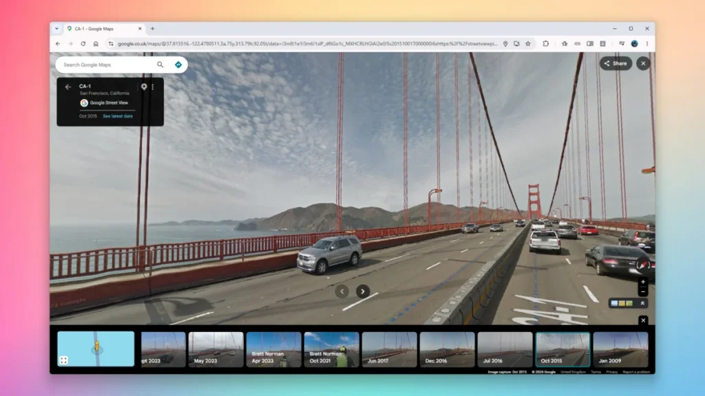
Accessing the historical layers of the world requires a specific set of steps depending on the platform used. For desktop users, the process begins by navigating to Google Maps and dragging the "Pegman"—the yellow humanoid icon located in the bottom-right corner—onto a blue-highlighted road. Once the immersive ground-level view is active, a small box appears in the upper-left corner of the screen. By clicking "See more dates," users activate a carousel at the bottom of the interface. This timeline allows for the selection of various months and years, dating back to 2007 in some regions.
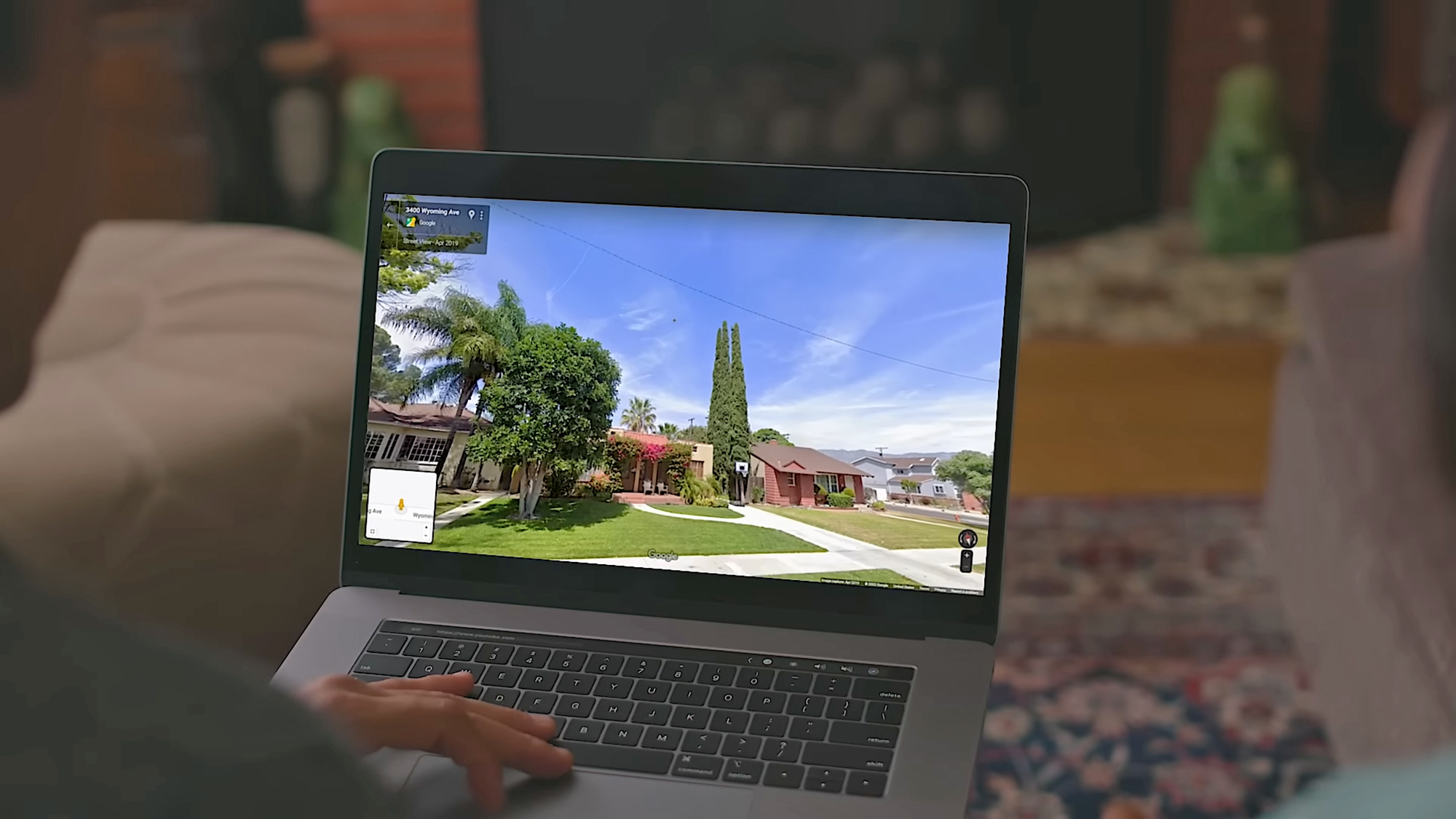
The mobile experience, though slightly different, offers the same depth of data. Users can long-press on a map location to drop a pin and then tap the Street View thumbnail. By tapping anywhere on the Street View image and selecting "See more dates," the mobile app provides a similar chronological list. This democratization of historical data ensures that anyone with a smartphone can witness the evolution of their neighborhood in real-time.
However, the availability of these "time slices" is not uniform. Urban centers like London, Tokyo, and New York City may have updates every few months, providing a dense timeline of change. In contrast, rural areas or developing nations may only have two or three data points spanning a decade. This discrepancy highlights the logistical challenges of maintaining a global digital twin and the varying levels of infrastructure investment across different regions.
Urban Planning and Environmental Implications
Beyond the novelty of seeing an old car parked in a driveway or a long-closed coffee shop, the "Time Travel" feature serves critical professional functions. Urban planners and historians use the tool to track gentrification, urban decay, and the effectiveness of zoning laws. For example, a researcher can visually document the transition of an industrial waterfront into a luxury residential district over a 15-year period, noting exactly when specific infrastructure improvements were implemented.
Environmentalists and disaster response teams also leverage this historical data. In the wake of natural disasters, such as Hurricane Katrina or the 2011 Tōhoku earthquake and tsunami, Google has often released "before and after" imagery to assist in damage assessment and reconstruction efforts. By comparing Street View imagery from before a storm to current conditions, NGOs and government agencies can identify which structures were lost and how the topography has shifted.

Furthermore, the data provides a unique look at environmental changes on a micro-scale. Users can observe the receding of glaciers in polar regions or the impact of prolonged droughts on vegetation in the American West. While satellite imagery provides a macro-view of these changes, Street View offers a human-scale perspective that is often more relatable and impactful for public awareness campaigns.
Privacy, Ethics, and Official Responses
The expansion of Street View has not been without controversy. Since its inception, privacy advocates have raised concerns about the unintended capture of individuals in private moments. In response, Google implemented automated blurring for faces and license plates. Additionally, the company allows property owners to request the permanent blurring of their homes.
From a legal standpoint, various nations have challenged Google’s right to map public streets. In 2011, Google temporarily halted Street View filming in Germany following significant public backlash and strict privacy rulings, though it eventually resumed with more stringent opt-out options. Despite these hurdles, the general consensus among digital historians is that the benefit of the archive outweighs the privacy risks, provided that robust safeguards remain in place.
In statements regarding the 15th anniversary of the service, Google representatives emphasized that Street View is intended to be a "living map." The company stated that the goal is not just to show where a place is, but to provide a sense of "being there," which includes understanding the history and context of a location. This vision has led to the development of "Immersive View," a newer feature that uses AI to fuse billions of Street View and aerial images to create a rich, digital model of the world that includes real-time weather and traffic data.
The Future of Digital Memory
As Google continues to refine its "Time Travel" capabilities, the potential for augmented reality (AR) integration becomes clear. Future iterations of Google Maps may allow users to hold up their phones while walking down a street and see a "ghost" overlay of what that street looked like in 1920 (via archival photos) or 2010 (via Street View).

The cultural impact of this technology is perhaps most visible in the realm of personal history. There have been numerous viral stories of individuals using Street View to find images of deceased loved ones sitting on porches or walking down sidewalks, frozen in time by a passing Google car. This accidental preservation of human life adds a layer of emotional depth to what is essentially a massive database of geographical information.
In conclusion, Google Street View’s time travel feature is more than a technical gimmick; it is a significant milestone in how humanity records its own existence. By providing a free, accessible, and comprehensive visual history of the world’s streets, Google has created a resource that will only become more valuable as the decades pass. Whether used for serious academic research or a simple trip down memory lane, the ability to "go back in time" on a digital map represents one of the most successful intersections of big data and human experience in the 21st century. As the archive grows, it will continue to serve as a testament to the constant state of flux that defines the modern world, ensuring that while the physical landscape may change, the digital memory remains intact.