


The cinematic depiction of storm chasing often involves high-stakes rivalries, sleek armored vehicles, and a near-constant barrage of atmospheric violence that suggests tornadoes are as common as afternoon rain showers. However, for professional meteorologists and seasoned field researchers, the reality of tracking severe weather across the United States is a discipline defined more by rigorous data analysis, logistical patience, and a low success-to-effort ratio than by Hollywood-style adrenaline. Cyrena Arnold, a meteorologist with over two decades of experience in the field, recently provided a comprehensive look into the professional world of storm chasing, untangling the complex web of fact and fiction that surrounds one of the most dangerous pursuits in atmospheric science.
The Hollywood Myth vs. Meteorological Reality
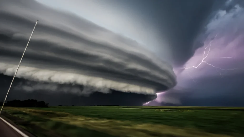
Popular culture, driven by the legacy of the 1996 film Twister and its 2024 successor Twisters, has cemented a specific archetype of the storm chaser: a rogue scientist or thrill-seeker engaged in a race against time and competitors. While these films capture the visual majesty of supercell thunderstorms, they often distort the operational reality. One of the most significant discrepancies lies in the frequency of tornado intercepts. According to Arnold, the "success rate" for a storm chaser—defined as witnessing a tornado—is approximately 10 percent.
In a professional context, a "bust" day is far more common than a successful intercept. Chasers may drive hundreds of miles across state lines, from Texas to South Dakota, only to have the atmosphere fail to "cap," resulting in clear skies or non-severe rain. Hollywood’s compressed timelines suggest that tornadoes are encountered within minutes of leaving a garage, whereas real-world chasing involves hours of "nowcasting"—monitoring real-time radar and satellite data from a parked vehicle in a remote gas station—waiting for the precise moment of storm initiation.
Furthermore, the trope of the bitter rivalry between chase teams is largely a fabrication for narrative tension. Arnold notes that the actual storm-chasing community is characterized by a high degree of camaraderie. When dozens of teams converge on a small town in Oklahoma or Kansas, the atmosphere is more akin to a professional convention than a race. Chasers frequently share data, discuss model outputs, and assist one another with vehicle repairs or navigation. This network of "ground truth" observers serves a critical role in the broader meteorological ecosystem, providing eyes on the ground that remote sensing technology cannot replicate.
The Scientific Mission: Data Over Drama
While hobbyists and "weather tourists" may chase for photography or personal thrill, the scientific community chases to solve the enduring mysteries of tornadogenesis—the process by which a tornado forms. Despite decades of research and the deployment of advanced Doppler radar, meteorologists still struggle to predict with 100 percent accuracy which supercell thunderstorms will produce a tornado and which will remain mere rain-producers.
Professional chasing involves the deployment of sophisticated tools, such as:
- Mobile Mesonets: Vehicles equipped with high-frequency sensors that measure temperature, humidity, and wind speed at the surface.
- Doppler on Wheels (DOW): Mobile radar units that can get close to a storm to scan the lowest levels of the atmosphere, often blocked by trees or terrain for stationary NEXRAD stations.
- Radiosondes: Weather balloons launched directly into the inflow of a storm to provide a vertical profile of the atmosphere.
The data collected by these teams is fed back into numerical weather prediction models, helping to refine the algorithms that the National Weather Service (NWS) uses to issue warnings. Arnold emphasizes that chasers act as the "eyes and ears" for the NWS. When a chaser reports a "tornado on the ground" via the Spotter Network or amateur radio, it provides immediate verification that allows forecasters to upgrade a Tornado Watch to a PDS (Particularly Dangerous Situation) Warning, potentially saving lives in the storm’s path.
Operational Hazards: The Dangers Beyond the Vortex
While the tornado is the most visible threat, it is rarely the most dangerous aspect of storm chasing. Professional chasers must navigate a gauntlet of atmospheric and logistical hazards that receive little screen time in movies.
Hydrological Threats
Flash flooding is statistically the deadliest weather phenomenon in the United States, and it poses a constant threat to chasers. Intense rainfall can turn dirt roads into impassable "greased" mud, trapping vehicles in the path of a shifting storm. Arnold recounts personal experiences where the special composition of Midwestern soil rendered four-wheel-drive vehicles useless, forcing a retreat on foot under the threat of lightning.

Lightning and Microbursts
Lightning remains an unpredictable killer. Chasers often stand in open fields to document storm structure, making them primary targets for cloud-to-ground strikes. Additionally, "wet microbursts"—intense downdrafts of cool air and rain—can produce straight-line winds exceeding 100 mph. These winds can flip vehicles or cause structural damage similar to an EF-1 tornado, often occurring with little warning as the storm collapses.
Human Factors and "Chaser Convergence"
One of the most modern hazards is "chaser convergence." As storm chasing has grown in popularity, the number of vehicles on rural roads has increased exponentially. This leads to traffic jams in the path of dangerous storms, making it difficult for emergency vehicles to pass and increasing the risk of multi-car accidents. Professional ethics in the chasing community now place a heavy emphasis on responsible driving and avoiding "cluttering" the roads during high-risk events.
Statistical Trends and the Geography of Risk
The traditional concept of "Tornado Alley"—a corridor stretching through Texas, Oklahoma, Kansas, and Nebraska—is undergoing a documented shift. Data from the National Oceanic and Atmospheric Administration (NOAA) indicates that while the Great Plains remain a hotspot, the frequency of tornadoes is increasing in the "Dixie Alley" region, encompassing Mississippi, Alabama, Tennessee, and Kentucky.
The Eastward Shift
This shift poses new challenges for storm chasers and residents alike. Unlike the flat, treeless plains of Kansas, the Southeast is characterized by "high-precipitation" (HP) storms, dense forests, and rolling hills. These factors make it nearly impossible to see a tornado until it is within a few hundred yards. Furthermore, the Southeast has a higher population density and a greater number of mobile homes, which increases the vulnerability of the local population.
Seasonal Expansion
Climate data also suggests an expansion of the traditional tornado season. While May and June remain the peak months for the Plains, destructive outbreaks are increasingly occurring in late autumn and winter. The December 2021 tornado outbreak, which devastated Mayfield, Kentucky, serves as a grim reminder that the atmospheric ingredients for severe weather—moisture, instability, lift, and shear—can coalesce at any time of year.
Official Responses and Public Safety
The relationship between storm chasers and official government agencies like the NWS and FEMA has evolved into a symbiotic partnership. The NWS "Skywarn" program has trained hundreds of thousands of volunteers to identify and report severe weather. This "ground truth" is essential because radar beams, due to the curvature of the Earth, often overshoot the lowest parts of a storm where a tornado actually makes contact with the ground.
Official responses to the rise of storm chasing have focused on education rather than regulation. Agencies emphasize that the public should never attempt to chase storms without extensive training in meteorology and navigation. The primary advice for the general public remains: when a warning is issued, seek shelter in an interior room on the lowest floor of a sturdy building, away from windows.
Broader Impact and the Future of Meteorology
The work of meteorologists like Cyrena Arnold extends beyond the field into the realm of science communication. By writing children’s books and hosting podcasts, Arnold and her peers aim to demystify the weather for the next generation. This educational mission is crucial in an era where climate change is altering the frequency and intensity of extreme weather events.
The future of storm chasing lies in the integration of unmanned aerial vehicles (UAVs) and artificial intelligence. Drones can now be flown into the core of a supercell to take measurements that would be too dangerous for a manned vehicle. Meanwhile, AI algorithms are being trained on decades of chase data to identify the subtle "signatures" of tornadogenesis before they appear on traditional radar.
In conclusion, while the movies provide a thrilling spectacle of nature’s fury, the real story of storm chasing is one of scientific dedication. It is a field where a 90 percent failure rate is accepted as the price of a 10 percent success that could lead to a breakthrough in public safety. As the climate continues to shift and the geography of risk expands, the role of the professional storm chaser as a sentinel for the public has never been more vital. Through a combination of historical data, real-time observation, and a commitment to education, the scientific community continues to chase not just the wind, but the knowledge required to protect society from the atmosphere’s most violent manifestations.