


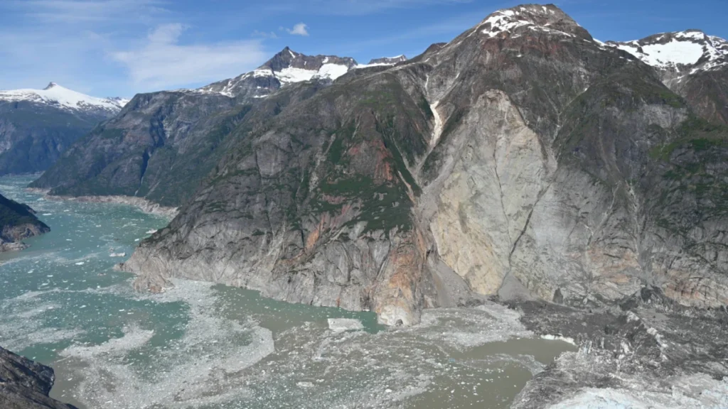
In the early morning hours of August 10, 2025, a geological event of historic proportions occurred in the Tracy Arm fjord of Alaska, sentry to one of the state’s most frequented maritime corridors. A massive rock avalanche, triggered by the destabilization of a steep mountainside, plunged into the deep waters of the fjord, generating a megatsunami that reached a peak run-up height of ,1578 feet. This wave, standing approximately one-and-a-half times the height of the Eiffel Tower, represents one of the largest landslide-generated tsunamis recorded in modern history. While the event occurred in a remote wilderness area, its timing was the only factor preventing a catastrophic loss of life, as the fjord is a primary destination for the Alaskan cruise industry, which hosts millions of visitors annually.
The event, detailed in a comprehensive study published in the journal Science, underscores a growing peril in high-latitude regions: the increasing frequency of landslide-generated tsunamis driven by rapid glacial retreat. Researchers from the University of Oxford, the University of Calgary, and the United States Geological Survey (USGS) utilized advanced satellite imagery and seismic modeling to reconstruct the event, concluding that the disaster was a direct consequence of the thinning ice and destabilized terrain associated with global climate change.
Chronology of the Event: A Narrow Escape
The disaster began at approximately 5:30 a.m. local time on August 10, 2025. At this hour, the Tracy Arm fjord, located within the Tongass National Forest about 45 miles south of Juneau, was largely devoid of the heavy maritime traffic that typically characterizes its summer season.
At 5:30 a.m., a massive volume of rock and debris detached from a northern slope above the fjord. The resulting landslide struck the water with enough force to displace a monumental volume of the fjord’s depths, sending a wall of water surging upward and outward. According to the USGS field reconnaissance conducted three days later on August 13, the tsunami stripped the surrounding canyon walls of all vegetation, leaving a visible "trimline" that marked the wave’s terrifying reach.
Witness accounts from those in the vicinity provide a harrowing look at the tsunami’s impact. A group of kayakers camping along the shoreline reported being jolted awake at 5:45 a.m. by the sound of rushing water. They described a sudden, powerful surge that swept through their campsite, carrying away gear and a kayak. Several miles away, near the mouth of the fjord, observers on a cruise ship reported seeing unusual white water and intense currents, though the wave had dissipated significantly by the time it reached the open sea. Another eyewitness on a nearby beach reported a residual six-foot wave striking the shore, a fraction of the initial surge but still capable of causing significant damage to small craft.
Experts note that if the landslide had occurred just four to five hours later, the outcome would have been vastly different. On a typical mid-August day, Tracy Arm fjord can host upwards of 20 large cruise ships, alongside dozens of smaller tour boats, private yachts, and groups of kayakers. The narrow geometry of the fjord would have left these vessels with no means of escape, likely resulting in a maritime disaster of unprecedented scale.
Scientific Detection and the Role of NASA Technology
One of the most concerning aspects of the Tracy Arm event was the lack of traditional precursor signals. Typically, large-scale landslides are preceded by "slope creep"—a slow, measurable movement of the mountainside that can be detected by ground sensors or satellite interferometry. However, Dr. Dan Shugar, a geomorphologist at the University of Calgary and a co-author of the study, noted that this specific slope gave virtually no warning.

"Normally with these gigantic rock avalanches, they often give some sort of warning signs in the weeks, months, or years prior," Dr. Shugar stated. "In this case, that didn’t happen. There was some minor seismic noise that was so slight it went completely undetected by regional networks until we looked back at the data."
To analyze the event after the fact, researchers turned to NASA’s new Surface Water Ocean Topography (SWOT) satellite. This cutting-edge technology allowed the team to observe the sea-surface structure of the event with a level of detail previously impossible. By comparing data from before and after August 10, the researchers could map the exact displacement of water and the subsequent propagation of the wave through the narrow fjord system.
Dr. Thomas Monahan, an engineer at the University of Oxford, emphasized the importance of this technological breakthrough. "Until now, we simply didn’t have a way to observe these waves directly," Monahan said. "SWOT data can reveal the full sea-surface structure of these events, even if no one witnesses them directly, providing a vital tool for understanding how these waves behave in complex environments."
The Climate Change Connection: Destabilizing the North
The Science study explicitly links the Tracy Arm landslide to the ongoing retreat of Alaskan glaciers. Data from the National Park Service and the USGS indicates that between 1985 and 2020, glacier-covered areas in Alaska decreased by approximately 13 percent. As these glaciers melt and shrink, they leave behind steep, unsupported rock faces that were previously buttressed by millions of tons of ice.
When this ice "buttress" is removed, the underlying rock is exposed to the elements and subjected to internal pressure changes. Combined with the thawing of alpine permafrost—which acts as a geological "glue" holding mountain faces together—the result is an environment primed for catastrophic failure. The USGS has categorized these steep, mountainous areas as "inherently unstable," warning that as temperatures continue to rise, the frequency of such landslides is expected to increase.
Landslide-generated tsunamis are particularly dangerous because they produce localized water inundation that can far exceed the height of tsunamis caused by tectonic earthquakes. While an earthquake-generated tsunami might reach heights of 30 to 100 feet, the displacement caused by a mountain falling into a confined body of water can create "megatsunamis" like the one seen in Tracy Arm. This phenomenon was famously documented in 1958 at Lituya Bay, Alaska, where a landslide triggered a wave that reached an incredible 1,720 feet.
Industry Response and Economic Implications
The Tracy Arm event has sent shockwaves through the Alaskan tourism industry, which is a cornerstone of the state’s economy. In 2024, approximately 1.6 million passengers visited Alaska via cruise ships, with Tracy Arm fjord being one of the most highly rated sightseeing destinations.

In response to the 2025 event and the subsequent scientific findings regarding the instability of the fjord’s walls, at least six major cruise lines have announced significant changes to their 2026 itineraries. Carnival Cruise Line was among the first to drop Tracy Arm fjord from its scheduled routes, citing the "unpredictable and inherent hazards" that remain in the area. Other lines have opted to replace the fjord with visits to Endicott Arm or Hubbard Glacier, though experts warn that these areas may eventually face similar geological risks.
The economic impact on Juneau and other coastal municipalities is expected to be significant. Local tour operators, who rely on the proximity of Tracy Arm for day-trips, face the prospect of permanent closures if the fjord is deemed too dangerous for commercial navigation. Furthermore, the USGS and the National Oceanic and Atmospheric Administration (NOAA) are now under pressure to implement more robust real-time monitoring systems in popular fjords to provide early warnings to vessels.
Future Outlook: Monitoring a Changing Landscape
The Tracy Arm tsunami serves as a stark reminder of the "cascading hazards" associated with a warming climate. It is no longer enough to monitor rising sea levels or melting ice caps; the secondary effects of these changes—such as tsunamis in areas previously considered safe—must now be integrated into public safety and infrastructure planning.
Dr. Shugar and his colleagues argue that the Tracy Arm "near miss" must be a catalyst for change. "Ultimately, what we hope is that coastal municipalities, the cruise ship industry, and other stakeholders take these threats seriously," Shugar said. The study recommends the deployment of more sophisticated seismic arrays and the use of automated satellite monitoring to detect minute changes in slope stability before a collapse occurs.
As the landscape of Alaska continues to transform, the events of August 10, 2025, will likely be viewed as a turning point in maritime safety and geological research. For now, the "trimline" along the walls of Tracy Arm stands as a silent, harrowing monument to the power of a changing planet and a warning of the challenges that lie ahead for those who navigate the world’s warming northern reaches.